MACIF and Banque Populaire looking good in the short term
Chart above courtesy of Expedition/Tasman Bay Navigation Systems and PredictWind
Positions at 0630
| Pos | Skipper | Boat | Lat | Long | Spd | Crs | Spd | VMG (Nds) | Crs | Dist | DTF | DTL |
| 1 hr | - | Between scheds | - | - | 24hrs | |||||||
| 1 | François GABART | MACIF | 34 42.76' N | 61 14.02' W | 12.9 | 74 | 10.4 | 9.5 | 30 | 244.6 | 2651.4 | 0 |
| 2 | Armel LECLEACH | Banque Populaire | 34 18.50' N | 61 00.92' W | 12.9 | 88 | 9.4 | 8.6 | 30 | 211.9 | 2662.8 | 11.4 |
| 3 | Jean-Pierre DICK | Virbac-Paprec 3 | 35 31.10' N | 62 20.03' W | 6.5 | 31 | 9.3 | 8.3 | 29 | 233.2 | 2671 | 19.6 |
| 4 | Vincent RIOU | PRB | 35 02.15' N | 62 08.74' W | 12.2 | 36 | 12 | 9.4 | 15 | 231.4 | 2677 | 25.6 |
| 5 | Mike GOLDING | GAMESA | 34 43.23' N | 62 16.43' W | 11 | 40 | 11.8 | 9 | 13 | 199.4 | 2699.1 | 47.7 |
| 6 | Marc GUILLEMOT | Safran | 34 29.27' N | 62 20.19' W | 12.5 | 55 | 11 | 7.8 | 9 | 181 | 2709.7 | 58.3 |
| 7 | Alex THOMSON | Hugo Boss | 34 51.80' N | 62 40.61' W | 9.8 | 35 | 11.9 | 9.6 | 17 | 190.4 | 2710.3 | 58.9 |
| 8 | Louis BURTON | BUREAU VALLEE | 31 52.96' N | 62 43.92' W | 5.2 | 75 | 5 | 4.9 | 66 | 122.1 | 2818.9 | 167.5 |
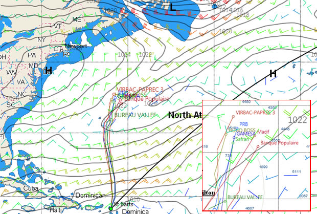
As the chartlet above amply demonstrates, the singlehanded IMOCA 60s racing in the Transat B to B are experiencing some very differing conditions at the latest sched. Out to the east, the two latest generation VPLP-Verdier designs MACIF and Banque Populaire are still in a favourable southwest flow with their big gear hoisted, while to the northwest Jean-Pierre Dick on Virbac Paprec 3 is suffering, his boat half the speed of those to the east, as he transitions into the northerly headwinds on the eastern edge of the high currently centred over the eastern seaboard of the States.
However the weather is rapidly changing. The GFS forecast has the high off the east coast of the USA moving east to the north of the fleet and ultimately north of the high to their east before the two merge over the course of Saturday night and into Sunday morning. If this proves correct then MACIF and Banque Populaire may be able to make hay over the next day and a half, gybing up the 90 mile wide corridor in favourable southwesterlies to the north of the lobe sticking out west from the high to their east. Meanwhile the boats to the west look set to be on the wind on starboard tack for the rest of today and will have to wait until tomorrow lunchtime for the wind to veer into the southwest as a depression forms off the east coast of the States filling the void left by the exiting high.
Come Sunday conditions will have evened out across the course and will allow the boats to enjoy strong favourable southwesterlies, the boats in the east set to benefit from this more. Beyond this the north Atlantic is looking like a meteorological war zone with another area of high pressure emanating from the east coast of the States over the course of Monday, bringing with it more (and strong) headwinds. Over the course of Wednesday a depression forms over Bermuda. The forecast indicates that this will be headbanger towards the end of next week, as it moves north and east, shoving the high off to the southeast with 40 knot southerlies to its south.
So it is safe to say this will not be the easy ride the forecasts prior to the start were indicating and there will be plenty of opportunities through the week ahead.

Businesses

Pro businesses
-
United Kingdom
-
-
Italy
-
Netherlands
Editor's choice
Member blogs
-
 Ned Collier Wakefield: MOD70 round BarbadosWell that was intense. 12 hard fought for seconds for the win. In idyllic conditions, Tony Lawsons MOD ...
 -
 Mini Transat leg 2 reportThe second leg of the Mini Transat started on 31st October, just over a month after ...
 -
Leg 1 reportI’ve been working towards the Mini Transat now for three years. In 2013 I was part ...
Business blogs
-
 The Island Sailing Club in Cowes, Isle of Wight, is delighted that Prince Michael of Kent ...
 -
Peta Stuart-Hunt chats with the 25 year-old British solo sailor Lizzy Foreman before she sets sail ...
-
The 2015 Student Yachting World Cup (SYWoC), an ISAF-recognised event hosted and run by students for ...
Editor's Choice
-
 Three legs down into Ian Walker’s
 -
 Winning all but two races at
 -
 For the first time in its
Latest Comments
Add a comment - Members log in