The weather call
Friday June 25th 2004, Author: Libby Greenhalgh, Location: United Kingdom
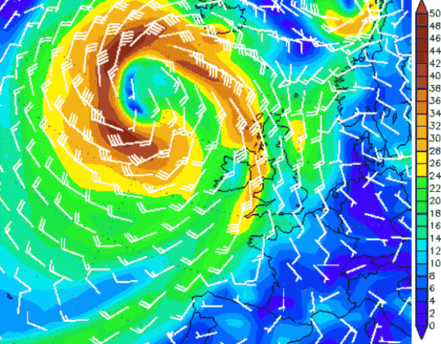
The ridge of high pressure that will dominate the UK weather for today will slowly drift SE allowing a mature depression currently in the Atlantic to move eastwards affecting the UK throughout Saturday.
As the mature low, centred to the NW of Ireland, tracks NE the trailing frontal sytems and southerly flank of the low will dominate the south of the UK's weather. The warm front is expected at 1400hrs with a cold front close behind and 1600hrs, both will be accompained by a marked veer in the wind.
Early doors Saturday (0600 hrs) will start with a 5 to 7 knot wind from 140 deg. By 0900 hrs the wind will have strengthened to 10 to 12 knots and veered to 160 deg.
Ahead of the warm front the wind will quickly build and the rain will intensify with windspeeds between 16 to 18 knots from 1100 hrs. As the warm front moves through the Solent (1400 hrs approx) the wind will veer to 180 deg.
The cold front is expected around 1600 hrs in the western end of the Solent and will be marked by a lowering in the cloud and heavier precipitation along with more unstable conditions. Winds will gust up to 28 knots and veer to 200 to 210 deg. Once the cold front is clear (1700 hrs) the wind will veer to 220 deg and moderate to 15 knots. Across the rest of the afternoon the cloud will slowly break and the wind will continue to decrease reaching 8 to 10 knots by 2000 hrs.
The Round the Island provides the unique opportunity to race to the south of the Island rather than in the Solent. This means your forecast needs to be adapted in various ways depending on where you are around the Island.
Firstly the Solent. The wind will be shifty and gusty as it bounces over the Island. With the wind funnelling down the river out of Cowes and into the western end of the Solent increasing the strength by between 2 to 5 knts. The wind will also be bending off the effectively veering as it comes off the land. The effect of this will be felt most within 200m of the land.
To the south of the Island the wind will be much cleaner as there are no obstructions and there will be a significant swell. The wind strength on average will be 2 or 3 knots stronger than in the Solent. While the direction will be up to 20 deg veered than in the Solent. The swell could vary between 5 to 7 feet to the south of the Island in comparison with the 3 to 5 feet in the Solent.
Finally there will be areas of convergence and divergence around the Island affecting the windspeed and direction with the two most significant ones on the Island shore:
A - At the needles where convergence will be occuring
B - At the eastern end of the Solent where divergence will be occuring.
Download the Bracknell chart for tomorrow... here
Websites for real data:
Weather buoys:
www.ndbc.noaa.gov/Maps/United_Kingdom.shtml
Windspeed and direction Cowes, Sandown, Solent:
www.weatherstations.co.uk/aws_map.htm
Latest radar satellite:
www.metoffice.com
If you have not already digested Pete Selby's navigational Pace Notes, now is the time to do it!
Part 1
Part 2


Latest Comments
Add a comment - Members log in