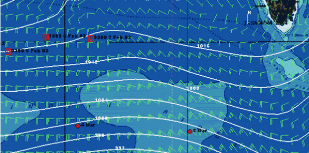
Red dots = Cheyenne. Red squares = Geronimo's 2003 attempt. Orange's relative position for 2002 is way off to the west. Weather for 0600 this morning
Running
Friday March 5th 2004, Author: James Boyd, Location: Transoceanic
|
Day 27
Position at 0505GMT: 52 14.630S 135 27.540E Course/speed: 079 deg 16 knots TWS/A: 26 knots/287 deg |
Cheyenne continues to stretch her legs as she approaches the longitude of Tasmania. Yesterday she covered 507 nm and is now around 1,700 miles ahead of Orange's 2002 round the world record.
At present she is still riding the strong northwesterlies associatied with a large depression to her southwest. But we'll let the navigator explain...
 From on board Adrienne Cahalan writes:
As we pass literally 'down under' I can hear the Formula One grand prix just above us in Melbourne warming up. So this weekend we will be in our red Ferrari firesuits here in the nav station just in case their is some pit action. As I have explained often to the Kiwi's on board (and that can take time and patience), there are other international events besides rugby and the America's Cup that can occupy the sporting mind, particularly in a land such as Australia where cultural and sporting stimuli are abundant. I also explained to them that that whole Lord of the Rings thing was a secret Hollywood pay-off funded by the CIA and orchestrated by George Bush to bring NZ back into ANZUS and then recommence visits to NZ by US nuclear war ships to dump nuclear waste. Sean Penn just got it a little wrong by giving the game away and mentioning WMD on Oscar night.
Yes, several of the Kiwi crew ask why we are blitzing through Australia at such a fast pace if it is such a great place to stay? Well the answer is simple. Our stay in Australian waters is positively leisurely when you compare it to the nano-second we will be under NZ. In fact when I did a crew survey on capital cities yesterday some interesting results came out. Many crew had difficulty identifying the capital of New Zealand while instantly each crew member was able to name Port-aux-Francais as the captial of the Kerguelen Islands, Tashkent as the captial of Ubekistan and Bishkek as the capital of Kyrgyzstan.
Back to business and weather wise our sail across the bottom has been going well as we have been able to sit just ahead of a cold front from as far back as longitude 70E until just 30 minutes ago when the cold front caught us. Therefore, the 25-35kt NW winds which have allowed us to sail at a fast angle of about 120 degrees wind angle (broad reach)and make very good miles (550+ per day) to the mark (Cape Horn) have shifted into the west. We are expecting that the wind will shift back into the NW and we will have another day of these good NW winds. If not, west winds mean that the Horn will be dead downwind, we will have to start gybing and clocking up 500+nm days toward the mark will be much more difficult to achieve.
All is not smooth sailing in these 25-35kt NW winds however, as we have had difficulty today and the last few days finding the right sail combination for this broad reaching angle and wind speed. We have wanted to stay at latitude 51-52S during this last week so we have had to do some reaching in 25-35 kts over the last few days which can be a little tough on the boat. We are aiming to stay on this latitude of 51-52S through out the weekend when we will pass under that small country east of Australia where a high pressure system is forecast to sit above. However, in order to be in a position to negotiate the high pressure system as we head into the South Pacific and to avoid the lighter winds associated with that high, we may have to sail a little more south toward latitude 53S. We always aim to sail in the belt of westerly winds located between the high pressures to the north (subtropics) and the lows to the south (sub polar latitudes).
Cape Horn is at an approximate latitude 57S and is now some 6000nm away. However, our overall strategy is that we do not want to drop south too quickly and would rather stay a little more north until closer to the Horn. As we cross from the South Indian into the South Pacific, we have not been in ice territory for several days. However, we anticipate that we will start to see some of those little bergs again in the South Pacific around about 120W which will be towards the end of next week.
Just a few little interesting facts:
Indian Ocean Sea temp at 50S has been about 6C and air temp 2C. Pacific Ocean Sea temp will be about 10C at 50S and air temp hopefully 6-7C.
The sky has been foggy with poor visibility and the occasional shower for several days. Last time we had a clear night sky was on Day 21 (today is Day 27) at longitude 53E when we thought we could see the reflection from the ice pack on this clear night.
The sea state has been relatively moderate (4m) and the swell from a Westerly direction.
Variation has gone from 60 W (NB compass best!) at longitude 90E to variation 1E (compass least!) at about 130E. We are close to the south magnetic pole. Many albatross and albatix continue to glide by and keep an eye on us.
The food remains poor but the company always good.
Most Read
Most Commented
Comments
Businesses

Pro businesses
Editor's choice
Member blogs
-
 Ned Collier Wakefield: MOD70 round BarbadosWell that was intense. 12 hard fought for seconds for the win. In idyllic conditions, Tony Lawsons MOD ...
 -
 Mini Transat leg 2 reportThe second leg of the Mini Transat started on 31st October, just over a month after ...
 -
Leg 1 reportI’ve been working towards the Mini Transat now for three years. In 2013 I was part ...
Business blogs
-
 The Island Sailing Club in Cowes, Isle of Wight, is delighted that Prince Michael of Kent ...
 -
Peta Stuart-Hunt chats with the 25 year-old British solo sailor Lizzy Foreman before she sets sail ...
-
The 2015 Student Yachting World Cup (SYWoC), an ISAF-recognised event hosted and run by students for ...
Editor's Choice
All time favourites...
-
 Three legs down into Ian Walker’s
 -
 Winning all but two races at
 -
 For the first time in its
Latest Comments
Add a comment - Members log in