MaxSea new release
Thursday November 27th 2003, Author: James Boyd, Location: France
Version 11 of Informatique et Mer's top navigation program MaxSea has been released.
This is designed to be easier to learn and operate and has a new interface featuring a redesigned Tool Palette, a new Chart Palette, a customisable NavData display, 33 short-cuts and an integrated help function.
Version 11 is also compatible with Mapmedia's mm2 charts. This new chart format provides unparalleled graphic quality thanks to it leading edge Wavelet ® technology.
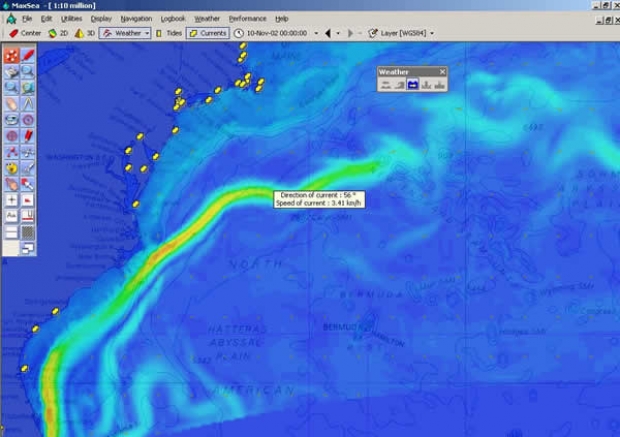
The program now comes with worldwide tidal height data pre-installed. Currents and tide can be displayed on the screen by a single mouse click. Judging from the increased importance of importing weather data such as GRIB files, MaxSea now includes its weather module as standard.
The company are also now selling their own hardware. The MSP is a special PC designed for use on board running MaxSea. They are also offering a software package for training purposes.
1000 Euros buys new users MaxSea v11 complete with tidal data, unlimited weather forecasts (supplied by MaxSea) 27 road maps and 30 Mapmedia electronic charts.
For more information click here

Most Read
Most Commented
Comments
Businesses

Pro businesses
-
United Kingdom
-
Netherlands
-
Italy
-
Editor's choice
Member blogs
-
 Ned Collier Wakefield: MOD70 round BarbadosWell that was intense. 12 hard fought for seconds for the win. In idyllic conditions, Tony Lawsons MOD ...
 -
 Mini Transat leg 2 reportThe second leg of the Mini Transat started on 31st October, just over a month after ...
 -
Leg 1 reportI’ve been working towards the Mini Transat now for three years. In 2013 I was part ...
Business blogs
-
 The Island Sailing Club in Cowes, Isle of Wight, is delighted that Prince Michael of Kent ...
 -
Peta Stuart-Hunt chats with the 25 year-old British solo sailor Lizzy Foreman before she sets sail ...
-
The 2015 Student Yachting World Cup (SYWoC), an ISAF-recognised event hosted and run by students for ...
Editor's Choice
All time favourites...
-
 Three legs down into Ian Walker’s
 -
 Winning all but two races at
 -
 For the first time in its
Latest Comments
Add a comment - Members log in