
Past Fernando de Noronha
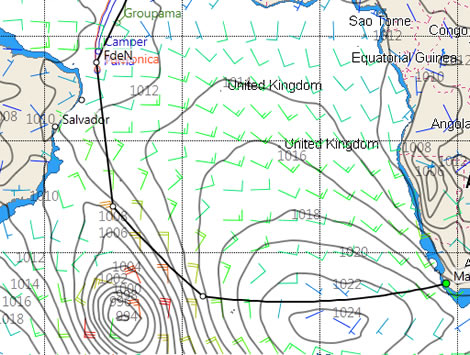
Chart above courtesy of Expedition/Tasman Bay Navigation Systems and PredictWind.
Unless Camper or Groupama get luckier than the leaders in the South Atlantic, by being better in phase with the weather system on this first leg of the Volvo Ocean Race, the race to Cape Town looks set to be a two horse race between Puma and Telefonica.
Puma crossed the Equator at around 1030 yesterday morning, followed by Telefonica at around 1200 and at 0405 this morning Ken Read's red boat was first to round the Fernando de Noronha mandatory turning mark, situated 190 miles off the coast of Brazil. Since then the two leaders have sped on in the easterly trades.
The tale has been less happy for the two boats behind. Camper finally crossed into the southern hemisphere at around 2300 last night and at the latest sched (0903) has 95 miles to run still before she reaches Fernando de Noronha. The situation is worse for Groupama which has yet to cross the Equator having spent most of yesterday struggling to ease herself out of the Doldrums. On her present course, attempting to get some westing in, she remains 130 miles short of the Equator. Surprisingly Camper has somehow gained a little ground over the last 24 hours and is currently 140 miles from Puma compared to 156 yesterday. Inevitably this is not the case for Groupama who's deficit on the leader has grown from 334 miles to 435 at the latest sched.
The lead duo will now be contemplating how to tackle the weather in the South Atlantic. The present situation is shown below with the St Helena high in the end of its phase exiting the South Atlantic. Its centre is currently southeast of South Africa. The European model has this high being squished towards the African continent in 24 hours time as another area of high pressure forms on the opposite side of the South Atlantic off the mouth of the River Plate between Uruguay and Argentina. In 48 hours time the forecast has the centre of the high to the east moving into the Indian Ocean as the high to the west starts shifting east. In 72 hours the high to the east is no longer in the picture and the high to the west is continuing east but still at a very high latitude. The St Helena should normally be centred somewhere around 20-30°S, but in this case its centre is closer to 40°S. Come next Monday the high is impressively straddling the entire breadth of the South Atlantic, still in the high 30s. A week from now the high is two thirds of the way to Africa and another area of high pressure is forming off South America...
So what does this mean? It means that the route for the leaders to get to Cape Town is probably going to be a long one. Given the movement of the high it looks like the leaders will probably have to sail somewhere in the region of 1700 miles due south or to roughly the latitude of Uruguay before they are far enough south to ease themselves east around the bottom of the high. This could be an opportunity for the boats behind to regain some miles as there may be more opportunity for them to 'cut the corner' a little more without the risk of running into no wind or headwinds.
Yesterday Telefonica skipper Iker Martinez concurred with this view: "It may be that we have to take a fairly long routing to get to South Africa, gaining a lot of south before making our way around the anticyclone and then gaining East to South Africa. It's still looking like we'll be fighting with Puma which'll be nearby, as both entries seem to be pushing forward at similar speeds and neither of us seem to let up for anything."


Businesses

Pro businesses
-
Netherlands
-
United Kingdom
-
-
Editor's choice
Member blogs
-
 Ned Collier Wakefield: MOD70 round BarbadosWell that was intense. 12 hard fought for seconds for the win. In idyllic conditions, Tony Lawsons MOD ...
 -
 Mini Transat leg 2 reportThe second leg of the Mini Transat started on 31st October, just over a month after ...
 -
Leg 1 reportI’ve been working towards the Mini Transat now for three years. In 2013 I was part ...
Business blogs
-
 The Island Sailing Club in Cowes, Isle of Wight, is delighted that Prince Michael of Kent ...
 -
Peta Stuart-Hunt chats with the 25 year-old British solo sailor Lizzy Foreman before she sets sail ...
-
The 2015 Student Yachting World Cup (SYWoC), an ISAF-recognised event hosted and run by students for ...
Editor's Choice
-
 Three legs down into Ian Walker’s
 -
 Winning all but two races at
 -
 For the first time in its
Latest Comments
Add a comment - Members log in