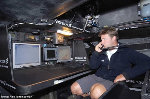
At the chart table
Friday December 30th 2005, Author: James Boyd, Location: none selected
This article follows on from
part one
of our interview with Ericsson Racing Team navigator Steve Hayles yesterday...
If you look back at the history of the Volvo Ocean Race and the Whitbread before it perhaps one of the biggest areas of development has been at the chart table. When the first Whitbread was held in 1973 it was unimaginable to take a computer on board a boat, navigation was by a sextant rather than a $200 palm-sized GPS set providing metre accuracy and long range communications were carried out using the romantic technology of high frequency radio, success dependent upon the mood of the ionosphere rather than a choice of satellite phone systems.
Gone are the teak chart tables of the Swan 65. Today a nav station on a Volvo Open 70 is made in carbon fibre, located in a small space below the cockpit the navigator's head perilously close to the drive shafts for the pedestal winches on deck.
The chart table on Ericsson for example features two fully plumbed in computers (navigator Steve Hayles prefers these to laptops) with keyboard and mouse, the display for the radar, the control box for the Inmarsat C terminal - the rest of the sat comms gear is at the media centre, a similarly sized space facing aft immediately behind the nav station - used primarily to maintain a flow of telemetry and position data from on board allowing race HQ to monitor and track the boat, a handheld GPS and the only pieces of equipment with any direct lineage from what might have appeared on a Swan 65 in 1973 - two display heads for the B&G Hercules 2000 system (the 1973 race winner Sayula 2 also had B&G gear) and an Icom VHF radio. In fact the gear at Ericsson's chart table is relatively sparce compared to what one used to find on maxi boats largely thanks to more and more operations, such the receiving of weatherfaxes or the display of GPS information, being handled by the computers.
GRIB wind vector file superimposed on an electronic chart - courtesy of Expedition Navigation Systems
The most powerful pieces of software Hayles uses are the sophisticated navigation and routing programs Deckman and Expedition. Both programs have a GPS input and are electronic chart plotters, allowing the position of the boat to be plotted continuously over an electronic chart. In addition to this at six hourly intervals the boats are sent the all-important position updates from VOR race HQ and these are fed into these programs, automatically plotting the positions of the competing boats on the electronic chart. Also ending up within these programs is the weather information sent through from race HQ such as GRIB files. These compact files can be used for pretty much any data but typically might include wind speed and direction information for a lattice of positions over a specific sea area (such as the Indian Ocean) forecast forward at hourly or three hourly intervals over a five day period.
Both programs also store the boat's polar performance information giving typical boat speeds for different wind angles and strengths. Where these programs really turn sophisticated is when the polars and GRIB data are combined to calculate the optimum route ahead for the forecast period. The result is a neat, easy to understand line the software plots across a chart (see below) showing the crew where they should be taking their vessel for the days ahead, including times to change course or to gybe or tack on shifts. But this comes with the very big assumption that the GRIB forecast data is 100% accurate, that the boat is being continuously sailed at exactly 100% and ignores major issues such as sea state, time taken during manoeuvres, etc. Thus 'routing' of this kind, as navigators are keen to point out, is an aid rather than the gospel truth leaving them still with a major interpretational role on board.

Expedition and Deckman have many many additional functions beyond the scope of this article and Hayles says he uses these two fairly similar programs for different reasons. "They do roughly the same thing in specific different ways. I also use lots of little utilities and bits and pieces. For example we get these meteosat pictures, tiled pictures and we have software to stitch them all together and animate them. Those things make life easy. For me it is always about making sure you have tools to do jobs quickly and efficiently. If you sit there and find yourself pressing thousands or buttons to achieve something you have messed up, you should have had a piece of software to do it."
Another utility Hayles says he uses often is a GRIB file viewing program. "One of the things you often want to do is to just sit there and watch the weather, scroll through it, look at it, shift it around and try and understand what’s going on. So there are a few little bits and pieces to do that."
In the Volvo Ocean Race this time navigators are prohibited from using the internet where Hayles says the downloading of weather information is the second biggest use of the web. However as in previous races they are allowed to use other publicly available sources of weather information.
Some boats for example are carrying equipment to receive images direct from polar orbiting satellites which in theory is all very cool for viewing the Doldrums or the Gulf Stream or clouds (in fact navigators such as Vincent Geake were using this kit back in the 1980s...) but Hayles takes the view that it is unnecessary. "If you ask people how much they use it, it is incredibly limited. The passes you get are limited and they are hard to animate. We receive, in my view, adequate enough satellite images [as part of Volvo's weather package]. I had no concerns about being compromised going through the Doldrums. My view of something like Gulf Stream data is to sit there and think that there is a boat bouncing up and down with inferior equipment - that you are in some way going to interpret that data and do a better job than someone sitting ashore with advanced, very high resolution imagery and sea surface altimetry data who's job it is to produce this current data - it seems rather big headed to me to think you are going to do a better job than they are. And it can consume an awful lot of time. The race in 1993 I used to spend all day trying to get weather faxes on the boat when you used to get tiny little 10k GRIB files."

There is a similar arguments for weatherfax. On Ericsson they picked up some weatherfaxes on the first leg, but Hayles says he found he already had this information in Volvo's weather package, including a better image of it, etc. Weatherfax is something of a dying technology, the UK Met Service, Bracknell for example dropped it years ago, but it is still strong in Australia and New Zealand and will be useful for the next two legs. Then there are radio broadcasts which for example would be useful for the coastal legs back in the northern hemisphere. "On this last leg - we always had the option of getting Guillermo [Altadill, Ericsson's Spanish crewman] to listen out past the Canary Islands," says Hayles.
When it comes to the hardware at the chart table Ericsson's navigator says that improvements over the last four years have been slight. To speed up and add functionality to their B&G performance instrument package, many boats are using the WTP system, effectively an advanced 'black box' for the instruments, developed by Graeme Wynn and since bought out by B&G. This is not new - Hayles says that he used this on Silk Cut two races ago, but since then its reliability has improved and some of its code has developed. "It gives a lot of user control, not in a simple sense, you need to know it well. Effectively it is a computer, a not terribly fast 486 processor, but compared to the processor you’ll find in an instrument system it is collasally fast. And you can make up new numbers and derive functions from different places and do a lot more sophisticated things with it which you find yourself needing to do with these boats with canting keel and canards and all sorts of other bits and pieces. You can measure these things but you also come up with functions that look at your performance data in different ways so it is a lot more configurable, etc."
While computer technology has come on in leaps and bounds, this makes processing faster but programs like Deckman and Expedition are still a fraction of the size of even something like Microsoft Word. Hayles is more concerned by less glamorous functions such as reliability and power consumption. The only occasion when a really fast processor could come in handy is if they start to run their own weather models on board. This for example could be used to forecast beyond the five days provided by Volvo. "There are ways of doing that and we have been running models but we didn’t do it on the boat on the first leg," says Hayles. "We could project further forwards than five days. but that is immensely processor intensive and it is incredibly hard to get any information out fast enough for it to mean anything. The processing time required to run even a relatively small grid is enormous and we don’t quite have the right data to initialise the models because the data is restricted to surface data. We do run our own stuff for in-port races."
One genuinely new piece of technology being used on three of the boats in the Volvo Ocean Race is real time kinetic (RTK) GPS. Back on terrafirma this equipment is used typically by surveyors to achieve highly accurate position fixing. This it does in a vaguely similar way to differential GPS where at a differential base station the inaccuracy within the GPS signal is perpetually calculated by comparing GPS-derived positions with that of the known position of the base station. The continually updated 'corrections' to this inaccuracy are then transmitted (on the basis that all GPS receivers in the vicinity will be subject to similar inaccuracy) and can be picked up by a differential receiver for example on a yacht. If this is correction is then fed into a differential-compatible GPS handset the result is very much more accurate position, particularly noticable in derived functions such as speed and course over the ground. RTK GPS goes a stage further - it compares one GPS receiver at a known position with another, but does so by examining the difference in phase of the GPS code being transmitted down from on high. The result is centimetre accuracy.
On board the VO70s however this gear is being used for a different reason. If two or more RTK GPS receivers are mounted on board a known distance apart then the difference in phase of the GPS signals between these receivers can be used to calculate extremely accurate and fast heading information. While gyro-compasses and quasi fluxgate/gyro compasses have been used extensively in the past to output fast accurate heading information, the performance of RTK GPS is very much superior and one could see it becoming very popular in the solo offshore community where having accurate and fast heading information not susceptible to yaw, could be used to drive an autopilot resulting in considerably fewer wipe-outs.
"There are some advantages in that compass errors disappear and Southern Ocean problems with compasses [to do with the magnetic pole) disappear," says Hayles.
To summarise, Hayles says that the nav set-up on the Ericsson in terms of hardware and software is not hugely different to what he used on board Tyco four years, however everything is slowly getting better and better. "Electronic charts are great and their accuracy is better, GPS is better, everything gets better, but there isn’t a radical need for anything beyond that. So small improvement everywhere."
Most Read
Most Commented
Comments
Businesses

Pro businesses
-
Italy
-
France
-
Netherlands
-
United Kingdom
Editor's choice
Member blogs
-
 Ned Collier Wakefield: MOD70 round BarbadosWell that was intense. 12 hard fought for seconds for the win. In idyllic conditions, Tony Lawsons MOD ...
 -
 Mini Transat leg 2 reportThe second leg of the Mini Transat started on 31st October, just over a month after ...
 -
Leg 1 reportI’ve been working towards the Mini Transat now for three years. In 2013 I was part ...
Business blogs
-
 The Island Sailing Club in Cowes, Isle of Wight, is delighted that Prince Michael of Kent ...
 -
Peta Stuart-Hunt chats with the 25 year-old British solo sailor Lizzy Foreman before she sets sail ...
-
The 2015 Student Yachting World Cup (SYWoC), an ISAF-recognised event hosted and run by students for ...
Editor's Choice
All time favourites...
-
 Three legs down into Ian Walker’s
 -
 Winning all but two races at
 -
 For the first time in its
Latest Comments
Add a comment - Members log in